
| "Palestine, Israel & Other Tragedies" |

"Palestine, Israel & Other Tragedies"
Part 2 of 2 Parts (Slides 68-127)

BEGINNING OF PART 2 (Slides 68-127) Click here to return to the beginning of Part 1 (Slides 1-67).

Slide 68
Our sixth visit is to At-Tuwani, a village in the arid south of the West Bank. There's a security barrier (fence?) not far south of At-Tuwani separating the West Bank from southern Israel, but we did not travel that far or see the barrier.

Slide 69
A view of At-Tuwani. Note older homes with domed roofs.
Slide 70
Maon, the Israeli settlement above At-Tuwani.

Slide 71
As we arrived in At-Tuwani, three Israeli soldiers were standing ominously on the hillside observing us and everything else happening in the village. The extra slide at the right is a blow-up from the slide at the left.

Slide 72
Arab children walking to school in At-Tuwani are sometimes following by Israeli soldiers and sometimes harrassed by Israeli settlers. Because of the tension created by Israeli settlers and the army, the Christian Peacemaker Team (CPT) maintains a permanent presence in At-Tuwani.

Slide 73
In this photo, two CPT members, one American & one Italian, talk to a gesturing member of my group. (Just outside the photo to the right is a one-room museum about the success of non-violent protest in Palestine.) The CPT team was withdrawn in October 2011 because the risk of Israeli harrassment had hopefully subsided.

Slide 74
Our sixth visit is to the "Tent of Nations" near Bethlehem.

Slide 75
A Christian family owns the farm on this hilltop. They call it the "Tent of Nations" in order to attract international attention & support. Note the Israeli roadblock in foreground. We had to park short of the roadblock & walk the rest of the way to the hilltop.

Slide 76
Israeli settlement, one of three which surround the "Tent of Nations." Settlers & Israeli authorities have harrassed the "Tent of Nations" owners for years, despite ownership records going back to 1916. Apparently the Israelis would like to cover this hilltop with another settlement.

Slide 77
A family member speaking to our group in a cave decorated by "internationals" who stayed awhile at the "Tent of Nations." This is the sister of Daoud Nasser who happened to be on a speaking tour of the USA at the time of our visit.

Slide 78
Local stone labeled in Arabic, English & German by a group of Germans who stayed for a time at the Tent of Nations. "We refuse to be enemies" is the motto of the "Tent of Nations."

Slide 79
Holocaust Memorial in Knoxville, Tennessee, made from local "Crab Orchard" sandstone. Note Jewish practice of leaving small stones at memorials.

Slide 80
Our seventh visit is to the Arab village of Bil'in a few miles West of Ramallah.

Slide 81
Map of the Modi'in "settlement bloc" showing how it extends into the West Bank from Israel on the left. This part of the border is very close to the Mediterranean. The settlements (shown in blue) are within easy commuting distance of Tel Aviv. Residents can see airplanes arriving & departing at Ben Gurion Airport. /// Highway 443 between Ben Gurion Airport & Jerusalem crosses this map. Unfortunately, the map does not show Modi'in itself just inside Israel proper (gray on the map).

Slide 82
This is Modi'in Illit, the Israeli settlement which looms above Bil'in. ("Illit" means "Upper" in Hebrew, but a Jewish friend of mine who used to live in Israel says English speakers often pronounce the word when applied to settlements as "Illicit.") The visible trees still belong to Bil'in, but the security fence cuts off many olive trees half way between the foreground & the settlement.

Slide 84
Our group facing Israeli soldiers at the security barrier. It was late afternoon, and I had to take this picture looking into the sun. This is where Bil'in residents & their guests protest the fence every Friday.
Slide 83
Three heavily armed Israeli soldiers. The one with stripes talked almost continuously on his field radio, no doubt keeping his headquarters informed about the presence of Americans at the fence.

Slide 85
This picture was taken looking away from the sun. So you'll not fail to see the tear gas grenades, I've circled them in red. This picture also shows how Israeli security fences occupy a very wide swath of land. On the Israeli side, a military road parallels the fence and adds to the amount of land taken from Palestinians.
Slide 87
I took this picture not far from the fence. Our Palestinian hosts asked us to look for "Made in the USA" labels on the tear gas grenades, but we didn't see any. Apparently the supplier to the Israeli Defense Forces has decided to obscure its identity.

Slide 86
This is a file photo showing Palestinians & "internationals" fleeing an Israeli tear gas attack at the edge of Bil'in. Our hosts showed us videos of more direct confrontations, including Israeli army vehicles in the village & tear gas attacks at the mosque.

Slide 88
This is a photo of the village of Bil'in taken from the security barrier. The red circle identifies the individual olive tree shown in the next slide.
Slide 89
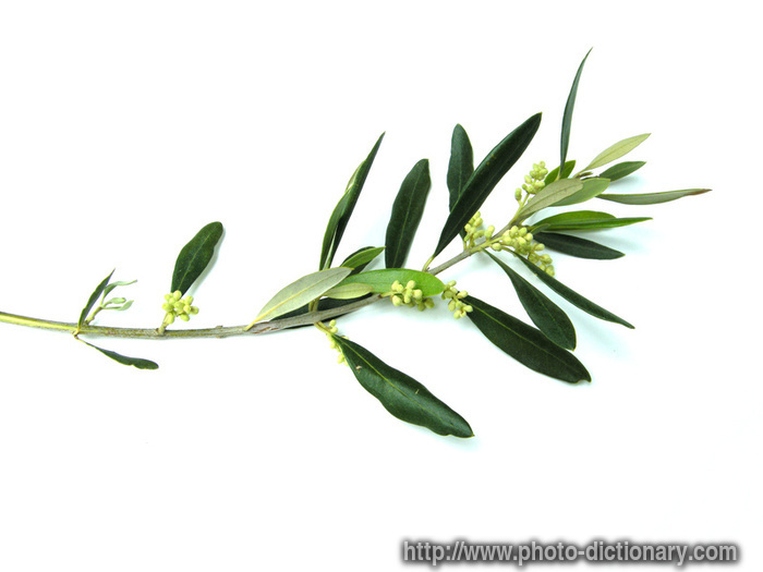
This is one of our Bil'in hosts. He's standing next to one of his olive trees which he thinks may be 1,000 years old. Olive trees have proper names. His family has called this tree Mahaseem for generations. The Israeli government destroyed trees such as this in order to build the security barrier between Bil'in & Modi'in. (The crop in the background is okra.) /// Ubiquitous throughout Palestine, the olive tree is the ultimate symbol associated with the concept of Sumud & with the Palestinian sense of rootedness in the land.

Slide 90
Our eighth & last visit is to Ma'ale Adumim, one of the largest of the Israeli settlements in the West Bank. You've already seen this map many times. This time, I want you to concentrate on many black dots which indicate some (but not all) of the Israeli settlements scattered throughout the West Bank on both sides of the security barrier. As you may recall, Israel removed four settlements the northern West Bank & all settlements from Gaza in 2005.

Slide 91
Ma'ale_Adumim is the blue area inside the red circle. This map also shows (1) how Bethlehem & Ramallah are, in effect, suburbs of Jerusalem, (2) how the State of Isreal has annexed East Jerusalem & beyond & (3) how intimately the newer Israeli settlements have been intermingled with the older Arab neighborhoods. The scale of this map is too small to show (4) how hilly this terrain is (with Ma'ale Adumim & other settlements generally occupying arid hilltops) & (5) the intricate network of security barriers & Israeli-only highways separating Palestinian & Israeli areas. We visited this area 3 times, once en route from Ben Gurion Airport to Bethlehem, once en route from Bethlehem to Ramallah & once on a guided tour of East Jerusalem.

Slide 92
To many in the USA & other countries, the Israeli policy of criss-crossing the West Bank with settlements & Israeli-only highways is not only illegal under international law but suicidal to the self-interest of Israel itself. But the Israeli government seems compeled to continue the practice. Of course one reason is to divide & weaken the Palestinians. But another reason is driven by the strong political influence of untra-conservative Jews (as in this file photo) who believe that Biblical prophecy dictates that Jews populate all parts of the Promised Land.

Slide 93
So this is what Ma'ale_Adumim (and other settlements) actually looks like up close. Ma'ale_Adumim is a modern city of some 39,000 residents with apartment buildings, single family homes, gardens, schools, synagogues, libraries, swimming pools, etc., etc. The so-called "settlers" easily commute to jobs in Jerusalem. /// Extra slide at right shows the Synagogue at 13 Hallil Street in Ma'ale Adumim. Note the representation of the hilltop settlement in the synagogue's stained glass. According to an Israeli website, "there are over 40 Ashkenazi & Sefaradi synagogues spread throughout Ma'ale Adumim, 4 mikvehs, a Hesder yeshiva, a kollel & several learning opportunities for men & women."

Slide 94
I got this image off of a real estate web site. It shows a Ma'ale Adumim home which its owner wants to sell. I'm told that settlement houses such as this cost far less than comparable properties in the older sections of Jerusalem & Tel Aviv. So -- just as in our country -- many Israelis choose a longer commute in order to get better housing for less money. /// Extra slide at right shows the "Bnai Zion Library of Peace" constructed in Ma'ale Adumim by the Bnai Zion Foundation of New York City (USA).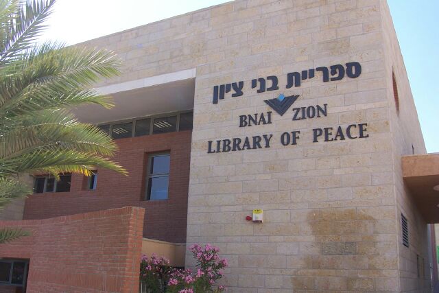

Slide 95
This is the interior of a Ma'ale Adumim shopping center. Look familiar? Remember that this is inside an illegal settlement for Jews only inside what is left of the State of Palestine. We did not visit this shopping center, but from the outside, I saw a sign for Ace Hardware -- same as near my home in West Knoxville. According to a company website, "Ace AutoDepot Ltd. is a public company, traded in the Tel Aviv stock exchange. Founded in 1993, the company holds 46 stores nationwide... ACE Israel is a franchisee of the American ACE Hardware chain comprising about 5,000 outlets worldwide." Extra slide at right is Peace Monument just outside the shopping center.

Slide 96
This photo was taken (not my me) inside the Ma'ale Adumim shopping center. (Note the "I love Israel" teeshirt.) We never saw American chains like this in the Palestinian parts of the West Bank. But we noticed Coca Cola products on both sides of the border; Cokes in Palestinian areas were all bottled in Ramallah. Palestinians complain about American companies which do business in Israel, particularly Caterpillar, a brand name highly visible on the giant bulldozers which Israelis use to destroy Palestinian homes & olive trees.

Slide 97
Showing photos of Ma'ale Adumim gives me a chance to mention "Boycott, Divestment, Sanctions" (BDS). Other members of the group I traveled with had already heard about the BDS campaign against Israel & Israeli products, and I was told about it repeatedly. Here is a design from the BDS website. The campaign's logo is a famous Palestinian cartoon character named Handala. He's a symbol of Palestinian resistance, and we saw him in grafitti all over the West Bank. /// In the intrerest of full disclosure, I confess an addiction to soft drinks & to Soda Club (also called SodaStream) which is a relatively inexpensive home carbonation system made possible by compessed CO2 & flavors imported from Israel.

Slide 98
Ma'ale_Adumim sparkles with modernity & cleanliness. Traffic zips up & down broad boulevards. I took this picture of a traffic circle from a moving bus. The olive tree is ancient & therefore had to have been moved here from somewhere else, doubtessly robbed from a Palestinian farm. Martin Luther King, Jr., Bouevard in Jerusalem is lined with such trees. I heard that representatives of the King family were invited to its dedication but refused to attend when they heard about the trees.

Slide 99
I took this photo of Nablus from the top of Mount Gerizim (seat of the Samaritans). Yes, that's an Israeli settlement on the hill in the background. Note the minirets of two or three mosques in the left foreground.

Slide 100
I'm jumping way South to show you a completely different kind of Israeli settlement. "The City of Hebron is the traditional burial site of the biblical Patriarchs & Matriarchs and is therefore considered the 2nd holiest city in Judaism after Jerusalem. Hebron is also venerated by Muslims for its association with Abraham & was traditionally viewed as one of the "four holy cities of Islam." In 1979, a group of orthodox Jews decided that God demanded that they inhabit the holy city. Today, Jews occupy the upper floors of buildings in the old Arab marketplace. I took the photo at the left to show steel framework & screening have been installed to prevent trash thrown from settlers' apartments from reaching Arabs on the street below. Sam Neff took the photo at the right to show an Israeli army patrol passing by members of our group as they shopped in the Arab market. The patrol turned up a side alley & appeared to approach a particular house (but I hurried on to avoid attracting attention).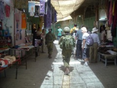

Slide 101
We were told that 1,500 Israeli troops are stationed in Hebron to protect 400 settlers. This is the Shavei Hebron yeshiva in the Beit Romano building of the Jewish quarter in Old Hebron -- although I didn't know all that when I took this picture. It's hard to miss seeing the ugly gun turret in the foreground. But a little harder to spot the floodlights & army observation tower on the fence in the middleground. Note the menorrah on the wall of the building in the background. Also note the yellow gate of the vehicle entrance at the left. After returning home, I spotted the same gate in many press photos of Palestinian demonstrations, such as shown in the extra slide at right.

Slide 102
As you can see, Arabs & tourists can walk right up the the fortress shown in the last slide. This is the very next photo I took. I didn't even notice the Jewish vehicle entrance -- or the incongriguity juxtoposition of innocent child and ugly fortress -- when I took this picture. But I'm always going to remember her as a smiling symbol of my visit to this land of tragegy & contrasts.

Slide 103
I'll also remember other smiling faces.These three kids live in the Dheisheh Refugee Camp in Bethlehem. (The third's in the shadow at the left.)

Slide 104
Here's a little Jewish girl with her mother in front of the Western Wall in Jerusalem.For the rest of this presentation, I'm going to show only people I want to remember.

Slide 105
A chicken worker in Hebron who wouldn't let me alone until I took this picture.
Slide 106
His buddy who ignored me as he steadily slit the throats of chicken after chicken.

Slide 107
Two of our Muslim hosts in Bil'in. The man at the left is the owner of the olive tree names Mahaseem.
Slide 108
Angela Godfrey-Goldstein, who showed us around East Jerusalem & Ma'ale Adumim.

Slide 109
Rafat Salsa, our guide from Bethlehem.
Slide 110
A bread seller in Ramallah.

Slide 111
A furniture maker in a Bil'in basement.
Slide 112
Three guys at a furniture store in Nablus.

Slide 113
A bird dealer in in the crowded market area of Nablus, West Bank.
Slide 114
A Jewish scholar reading in front of the Western Wall (aka Wailing Wall) in Jerusalem.

Slide 115
Four armed soldiers on the Mount of Olives overlooking the Old City.
Slide 116
An armed female soldier talking on her cell phone at Yad Vashem.Extra Slide
Haredi (ultra-
orthadox) girl in Ma'ale Adumim.

Slide 117
A Palestinian selling David Reese a ride on his donkey at the Mount of Olives.
Slide 118
A Jewish gentleman strolling on what was the Green Line before the Six Day War in 1967. That's West Jerusalem on the left & a wall of the Old City on the right.

Slide 119
A lady from England who's lived her entire adult life on a kibbutz near the Sea of Galilee. She married a Sephardic Jew, converted to Judaism & now walks from home to work at Yardenit, a Christian baptismal site on the Jordan River.

Slide 120
A Nigerian priest at St. Anne's Church in the Old City
(seeming delighted to learn that I'd once lived in Nigeria).

Slide 121
Jean Zaru, clerk of the Friends Meeting in Ramallah, West Bank.
Slide 122
Two commuters early one morning in West Jerusalem. (I took this photo from an airport van as we picked up passengers all over the city.)

Slide 123
A father & his daughter -- two of our Christian hosts in Bethlehem.
Slide 124
A Muslim man & his wife -- our hosts in Bil'in.

Slide 125
A brother & sister say good-bye at the "Tent of Nations."
Their family's lived there for 95 years.
But what's the future of their tragic land?
Slide 126
Here's her answer: "We don't know."

Slide 127
And neither does our guide in the Dheisheh Camp.This is where I'm leaving you. I have just showed you the pictures of 17 Muslims, 13 Jews, five Christians, one Quaker, one African, 23 men, six women, and ten children. They & ten million others remain in Palestine & Israel.
I hope they'll find peace. But their future is uncertain.

Slide 128
THE END
Click here to return to the beginning of Part 1 (Slides 1-67).
Click here to return to the beginning of Part 2 (Slides 68-127).

Extra
Slide- Peace Bell (Bonsho), Sacher Park, West Jerusalam (Israel). Cast in Shiga Prefecture (Japan). Dedicated in April 1996. Inscribed "Pray for the peace of Jerusalem. They shall prosper that love thee as well." Paid for by a group of people represented by Mr. Rikihiro Madarame, founder of Nemic-Lambda, a top producer of power-switching equipment.
Extra
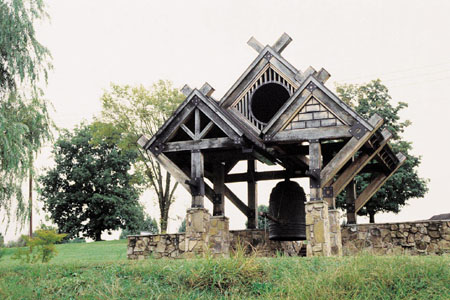
Slide- International Friendship Bell, A.K. Bissell Park, Oak Ridge, Tennessee (USA). Cast in Kyoto (Japan). Dedicated in May 1996. Inscribed with the dates of Pearl Harbor, Hiroshima, Nagasaki & V-J Day. Paid for by contributors from Oak Ridge, sister city Naka-Machi & the Atomic Energy Society of Japan.
Extra
Slide
Extra
Slide

Extra
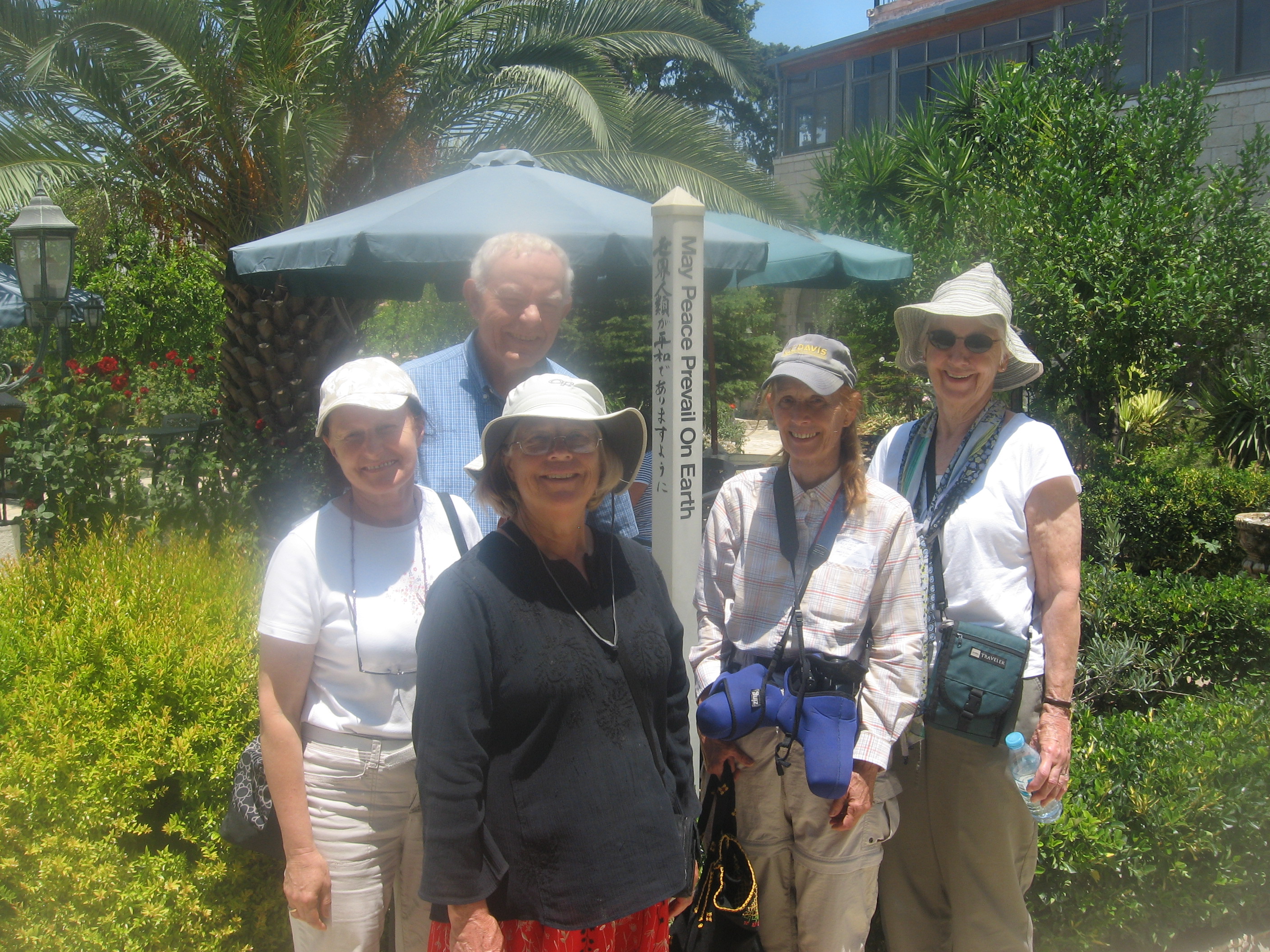
Slide- Our tour group posing in At-Tuwani (West Bank) on June 17, 2011.
Click here for more information.
|
Then page down & choose a link to one of more than 400 web pages. | Loading
|
